Tuesday 30 July 2013

A Loughton Circular Walk

I'd never been to Loughton and when the opportunity for a walk through Epping Forest with some of my good walking buddies came up I couldn't refuse. We estimated that it would be about ten miles and with the weather looking good, if a little hot, we arranged to meet at Loughton Station. I'd been through part of the forest before on the LOOP when it passed through Chingford and Buckhurst Hill.

The Route - More or Less

Heading from Loughton Station, which is the third of the name to be built - it seems to have moved about quite a bit, though only the latest, built in 1940 was built for the London Underground. It has particularly attractive gull-wing platform awnings but other than that it isn't anything to write a blog about. Head up Station Road past Lopping Hall (the site of the original station) which was built by the Corporation of London to compensate villagers for the loss of lopping rights in Epping Forest. It is an attractive building with a terracotta frieze showing people lopping branches above the door. Turn left down the high street, then right up Upper Park to Nursery Road, cross this and road and pass beside the nursery and enter the edge of Epping Forest. Turn right on a path heading towards Strawberry Hill ponds. It has to be said the route here is not clear until you find a gravel path leading through the forest.

We were surprised to see lots of small frogs or toads hopping across the gravel path - no more than a few centimetres long - a long journey for them across hostile terrain.

Odd Truncated Branches
Past the ponds you continue north eastwards until you meet and cross the A121 near a small car park. Continuing along the path on the other side of the road you head towards the earthworks at Ambresbury Banks but turn off sharp left before you reach them. The were several odd looking trees in this part of the forest, but as none of us had thought to bring an identification book with us - here is a picture instead.


Bracken Uncurling

There was a lot of bracken in the areas where the tree canopy was broken and the sunlight could stream down.

Heading north after crossing the B1393 you head up a quiet lane to the tall wrought iron gates and a pair of lodges. At first it wasn't clear how to get through till we spotted a small finger sign pointing to a sign gate that wasn't locked just stiff. The next section was a contrast to the earlier part of the walk as this was obviously a managed woodland with specimen trees laid out in an organised fashion. Carrying along the main path you start to notice the M25 for the first time, a constant drown of traffic noise which grows louder and louder until you cross it via a high level bridge.

The landscape changes instantly you cross the M25, becoming open rolling countryside and farmland on both sides of the track and before long you see the run down and ramshackle buildings of Copped Hall ahead on the right. They hold regular events, fund raising for repairs, but it appears to be almost impossible to get there other than by a bus that stops back at the lodge gates. That's fine in the summer but in the winter it might be harder to get people to turn up.

Borage Fields
Passing some rather nice cottages with well tended gardens you turn right past a pond then take a path diagonally across a field at the junction of two tracks (not easy to spot at first). This goes across a field of borage that was being ploughed in as a green manure. The drooping purple flowers and fluffy silver edged green leaves were a mass of fat bumble bees and the air was heavy with their buzzing.

The path, which is not clearly marked on the ground but aim at the yellow topped post on the far side leads into a track that climbs through a glorious meadow filled with wild flowers, bees and butterflies. 


Butterfly on Wild Flower
Bee on Wild Flower


The trail becomes a track that leads into the village of Copthall (note the change of spelling) Green and Upshire which has a fine village sign. Turning south along the Forest Way you recross the M25 by another high level bridge and you can just about see the one you came across earlier in the distance to your left.
You follow this clear path all the way to the High Beech Conservation Centre. Before you reach it there is a large car park where there is a large pub and a little bothy selling cold drinks and ice cream. We paused for a while to recharge our batteries before heading south back towards Loughton.It was a bit of a strain getting going again after sitting on a rather rickety wooden bollard but the pain in my hamstrings distracted me from my stiff knee.

Passing a finger post with a dispiriting "3 Miles to Loughton" indicator and plunging downhill past a pond and then up hill again we reached the outskirts of civilisation once more. This end of Loughton was very hilly and full of rather attractive properties. None too soon we reached the high street and our final destination, a slap up meal in Loch Fyne.

All in all a very pleasing walk with lots of variety and plenty to enjoy which probably turned out to be closer to twelve than ten miles. Well worth the effort.

Tracking the Tube: Metropolitan Line: Leg 02: Finchley Road to Wembley Park


Weather: Hot and Sunny
Distance Walked: 8.7km
Distance By Tube: 7.24km
Stations Visited: 2
Fantastic Plaice: Ever Fresh Fish Cricklewood


The second leg of the Metropolitan Line starts, unsurprisingly, from where I left off. The challenge this time for a walk that only includes two stations was two fold. First to avoid the Jubilee Line stations  that lie on the long stretch between Finchley Road and Wembley Park and how to get across the North Circular road without going too far out of my way.  Leaving Finchley Road and heading north past the wonderfully named Finchley Road and Frognal overground station I was glad to swing west off the busy A41 and enter the shaded and rather attractive side streets of this part of hilly Hampstead. Returning very briefly to the Finchley Road I spied across the busy thoroughfare one of my favourite eating places, Koi Sushi. Many a happy evening has been spent there after a long D&D session and it can be highly reccomended.

Heading down hill past many attractive Edwardian(?) mansion blocks and a very picturesque fire station dating from 1901 you reach Mill Lane which has a very nice village feel. That is something that you pick up when you walk through London, although everything at first appears to be one huge homogeneous metropolis, on the ground many places have kept a part of their original village feel. Hampstead is one of these and even within Hampstead there are different sub-villages and districts.

As the road turns north-west to follow a deep railway cutting there is a small nature reserve tucked into the side of the road. Westbere Copse is quite small and I should have spent a few minutes exploring it but I wasn't sure at the time if there was another way out.

The further north-west I walked along Westbere Road the less attractive the buildings on either side became, you really feel a sense of leaving Hampstead behind and moving into Cricklewood. Ah Cricklewood, this was one of those place names that had a magical attraction for me in my youth as it was the home of The Goodies. I had no idea where it was or what it was like so I made sure that today's walk passed through it. It is quite a busy, bustling place built around and along the A5, the old Roman Road that became in Anglo Saxon times, Watling Street. No sense of ancient history remains in the shop lined street of today though one shop Ever Fresh Fish had one of the finest displays of fresh fish I had ever seen. Fish from all corners of the globe (OK why do we say 'corners of the globe'? Globes have no corners!) bright eyed and very fresh looking. Didn't buy any as I think they may have been a little less fresh by the time I arrived at the end of the walk - it was beginning to get very hot indeed now and the shelter provided by the tall blocks either side of the road was balanced against the fumes from the lorries, buses and cars.

Beyond Watling Street the walk became more peaceful, with parallel streets of residential terraces running south of Olive Road, one of the houses had a very fine dragon finial on their roof which I coveted. I've seen them for sale in reclamation yards, including one near my office in Vauxhall, but they are too expensive (and too heavy to pop in my rucksack) so perhaps in our next house. One of these side streets had my favourite name so far, Dicey Avenue. It would be interesting to find out why that name was chosen, there is no pattern that I could determine; Sneyd,Wren, Dawsons, Blackstone and Heber are the others nearby. It all seems like a difficult Only Connect wall.

A very pleasant walk through Gladstone Park followed, lots of nice trees and . This is one of the numerous municipal parks that are dotted throughout London and which made walking the Capital Ring and this latest project so pleasurable. We are very lucky in London to have so many of them and we need to make sure that in this era of austerity we don't lose them or let them fall into disrepair.It had an interesting bird sculpture which reminded me a bit of some of the art in Barcelona's Park Guell.

Leaving the park, with great views of Wembley Stadium ahead, you enter Neasdon and not far ahead the drone of the North Circular starts to make itself heard. After all my worries it was actually very simple to cross. Following Neasden High Street leads to a very attractive underpass (yes they do exist and not all smell) with tiles depicting canal boats, trains and other forms of transport. I realised as I emerged back into the sunlight that I had been across the top of the underpass on the North Circular hundreds of times but never thought anything of it. A slow climb and walk along a rather busy main road followed before diving south west again towards the station at Wembley Park which has a very attractive frontage. It has obviously been upgraded recently to accommodate extra visitors for the new Wembley Stadium and this has been done very nicely giving the station a nice open feel.

That completed this leg of the walk and next time I need to make a decision as to which branch of the line to tackle first: south to Uxbridge or north to  Chesham, Amersham and Watford.


Monday 24 June 2013

Tracking the Tube: Metropolitan Line: Leg 01: Aldgate to Finchley Road


Weather: Cloudy and Humid becoming Sunny and Warm
Distance Walked: 12.2 km
Distance By Tube: 10.0 km
Stations Visited: 10
Fantastic Place: Primrose Hill


http://en.wikipedia.org/wiki/Metropolitan_line
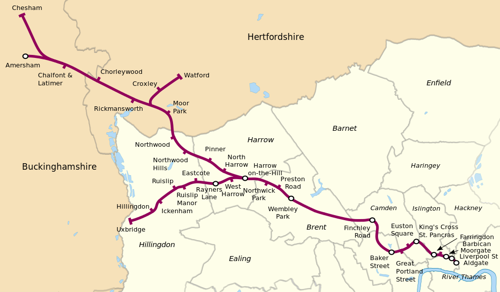
Metropolitan Line Map (from http://en.wikipedia.org/wiki/Metropolitan_line)

The 10 Stations
So the first leg of a new challenge. I'm not sure if I've ever travelled to Aldgate before, I certainly didn't recognise the area when I got out! Turning around the first thing I saw was the skeleton of a wooden framed building.

According to the plaque on the ground this marks the location of the historic Aldgate where Chaucer lived from 1374 to 1386. Behind it is one of the iconic new buildings that are dominating the London skyline - the Gherkin. The timber building is inspired by two poems by Chaucer while resident in the two rooms above the now long demolished gate.

The route between Aldgate and Liverpool Street is made more complicated by the amount of building work that is taking place in the heart of London at the moment. Below ground you have the Crossrail project that is well under way now. This means that streets are blocked off as they build new stations, extend existing ones and insert new ventilation shafts and what not.

Around Liverpool Street I found my favourite street name of the walk; Frying Pan Alley. The area has gone upmarket a bit since Jack London wrote about it and there are now parts of the University of East Anglia nearby, many upmarket sandwich shops, wine bars and other services for those travelling into and out of London via one of the busiest mainline termini.

As a part-time baker and the son of a professional baker I liked the images above a sandwich shop near the station. It's a narrow street and I wonder how many people spot these on their rush to buy lunch?

Moving on past Liverpool Street I encountered the first of many diversions due to building above ground as well as more Crossrail works. New office towers are being squeezed into whatever space is available, whether it be by demolishing an ugly 1960's block or into the space between existing towers. One of the spaces I was looking forward to seeing was Finsbury Circus, an oval oasis of green in the glass and concrete world of the city. However this was currently occupied by some of the aforementioned Crossrail works and only a small part was visible. What was open to view looked very nice though and my walking of another of the lines may bring me back.

More diversions on the route to Moorgate station and then a trudge past, around and under the Barbican centre  to Barbican station. I should have walked through the centre rather than around it but I missed the entrance! I always fancied living in the Barbican if I had to live in the centre rather than being able to live in the suburbs. Lots of culture including the Museum of London on your doorstep and some interesting, others may call it ugly and brutalist, architecture.

Between Barbican station and Farringdon I walked along the appropriately named Cowcross street, appropriate as this leads from the fabulous edifice of Smithfield market, the largest meat market in the UK and one of the largest in Europe. There has been a market on the site since the Middle Ages and the current building dates back to the 1850s.

It was also the place that Wat Tyler, leader of the Peasants' Revolt was executed. Sadly there are plans at the moment to demolish part of the historic market as part of a redevelopment plan.

From Farringdon you enter Clerkenwell, a arty-crafty part of London and as I have been before, I was surprised to come across St John's Gate which spans St John's Lane and which was part of a priory owned by the Knights Hospitallers. It's not often I manage to go on a walk that combines two of my favourite hobbies - cooking and Dungeons and Dragons!


After the pretty and historic area around Clerkenwell its a bit of a shock to emerge into the busy, bustling and rather shabby area around King's Cross and St. Pancreas and it is a relief to get off the main drag and into some side streets for a moment, though not before you pass two of my favourite buildings; St Pancreas Station and the British Library.

In one of the quiet squares south of King's Cross there is a statue of Gandhi, a nice peaceful reflective space in amongst the hubbub of the city.

However before long you are back on the main drag to visit Euston Square station and then not much further along, but feeling it because of the busy Euston Road, Great Portland Street station.

More trudging along this busy arterial route follows but at least there are some interesting buildings on either side, along with a huge queue of people outside Madame Tussauds. Now as a Londoner there are many of the famous tourist destinations that I have never got round to visiting, but I will do one day. This however is one that wild horses wouldn't drag me into! Especially when I saw how expensive it was - phew!

Baker Street station is just off of Euston Road and outside it is a plaque celebrating that this was part of the original underground network, built some 150 years ago. Humming Gerry Rafferty's Baker Street as I turned up the street of that name I passed a crowd of tourists taking photos of the actor dressed as a Victorian bobby outside of the famous detective's house at 221b before heading off into Regent's Park. The direct route would have taken me along the busy Finchley Road to the next station but this walk isn't about following the shortest route, but one that leads me through new and interesting places where possible.

Now Regent's Park is one of London's great open spaces and one that I had never visited before. It is a lot larger and in some places wilder than I imagined especially once you have crossed the bridge across the lake and headed into the northern half of the park. There are some nice sculpture in the park as well as great views of the Post Office tower.

Exiting the park past the London Zoo, no I've not been there either, not even as a kid when I was brought up to London by my long suffering elder sister as a birthday treat, you enter another fabulous open space Primrose Hill.

The views from the top of the hill are amazing and you realise how hilly London is with Hampstead and Harrow also on the walk on other parts of this line and elsewhere it won't be a flat trudge that's for sure.
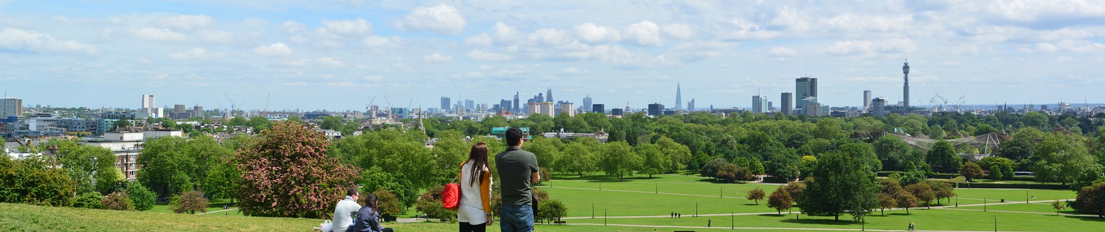
Primrose Hill: http://farm4.staticflickr.com/3698/9042771895_d046cba0fb_h.jpg
Primrose Hill
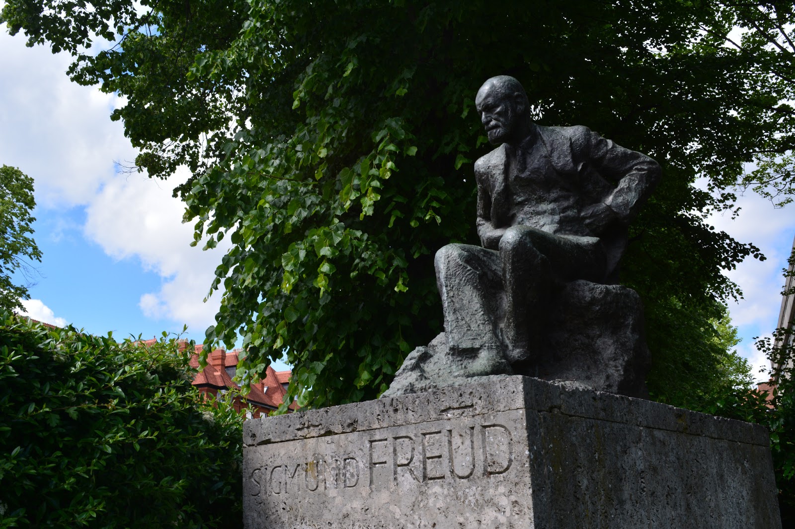
After finding my way out of Primrose Hill you pass through residential areas, in the garden of one house was a statue of Sigmund Freud,  before plunging down a narrow and rather steep alley to rejoin the Finchley Road and the station of the same name.

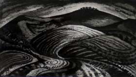
Possible idea for my next D&D adventure...
This is one of my regular stops as I have friends nearby but it was interesting to approach it from a new angle.

All in all a very enjoyable walk, it was good to get my boots back on and stride out after far too long thinking about what I was going to do rather than doing it. Looking forward to the next leg northwards along the line towards Wembley.


A New Project

I've been looking for a new project for some time - since I finished the London LOOP. For a while I thought about walking the Grand Union from London to Birmingham but wasn't sure if the transport links would be suitable. I could do part of the Thames Path from Oxford eastwards but west of Oxford transport gets too time consuming (and expensive!) so that one will have to wait, I may do the western sections when I'm visiting my relations in the Cotswolds.

So I was just browsing in the wonderful Pitshanger Bookshop a week or so ago and I came across Walk The Lines by Mark Mason. This details his walk along and around London's underground network. Within a few pages (while still in the bookshop) I had been inspired to do the same. I'm not as hard-core as Mark so I won't be doing 30+ miles in a day, instead I'll be splitting it up into smaller sections (6-10 miles a day) so it will take me a few years to complete.

Once I got home I found someone else, with the confusingly similar name of Mark Moxon had done the same thing and detailed it on his website. This is divided up into legs of a more manageable length and it is this approach I will take, but I won't be following exactly the same route. Instead I will look at the area around the line and see what interesting sights I can find and the route is likely to change as I walk the route as I get distracted easily! It will be interesting to see how I feel about:
  • A walk that is predominately urban in nature
  • A walk that I will be planning myself rather than following someone else's route
  • A walk that will revisit some places more than once (the Jubilee and Metropolitan lines share the same route for example as well as some stations being a nexus for several lines).

I'll be starting with the Metropolitan Line from Aldgate to Finchley Road.

Tuesday 11 June 2013

Strolls in Sussex: Two Rings to Rule them All

Weather: Warm and Sunny

This was a simple but very pleasant walk between two Iron Age hill forts in West Sussex. What made it extra special was that I could do it with my wife and being that it was pretty much on the level on wide tracks we could do it side by side discussing what we saw on the way. On hillier routes Liz normally complains that all she sees is a rather large backside...

Anyway... we started the walk by walking around the ramparts of Cissbury Ring, the largest hill fort in Sussex which dates back some 5000 years. From the ramparts you get fantastic views out to the coast and across the Sussex Downs. It was lambing season and everywhere you looked the lambs were gambling and bleating in a very cute fashion. It also gave me an idea for a game to play on walks - lamb bingo. Each lamb tends to have a number on it to match it with its mother so it would be easy to carry a bingo card with you and when you see a lamb or ewe with the appropriate number you can tick it off on your card.

I am not a number, I am a free lamb

After walking around the ramparts (a group was actually jogging round which I felt was a bit extreme) you return past the small car park (I would like to point out that the track out to the ring could have been better signed we kept getting lost in the little village before finding the correct track) and along a wide chalk track with Chanctonbury Ring in the distance.
Chanctonbury Ring by Jeremy Blighton
Like the Long Man at Wilmington, we were inspired to do this walk by our shared love of the ancient landscape and our etching by Jeremy Blighton.

The walk is easy as all you need to do is follow the wide track, keeping the tree capped hill of Chanctonbury Ring in view.

Eventually you reach a signpost marking the junction with the South Downs way - something we seemed to cross with somewhat scary frequency on many of the main roads we travelled on our holiday. If I was going to walk the South Downs way I would be concerned at the number of times I had to cross bury dual carriageways - especially if it was towards the end of a long hot day. I remember the same thing happening on the London LOOP, after you've walked twelve miles in the rain or sun there is very little left in the tank for rapid acceleration!

Chanctonbury Ring is smaller and covered with a cap of trees giving it a much more mysterious feel to Cissbury Ring and proved to be a more than acceptable picnic stop before we returned along the same track, this time with a view of Cissbury Ring to guide us back to the car all the while red kites circled around on the strong thermals.


Strolls in Sussex: The Long Man of Wilmington

Weather: Warm, Sunny and Breezy

Sussex is a county I've not visited since I was a lad, growing up on the south coast of Hampshire. We used to visit relatives in the Chichester area but we never ventured much further east. Having timed our visit during the only week of good weather we seemed to get this Spring I decided to make the most of it with a six mile walk around one of the most striking landmarks in the area - the Long Man of Wilmington. One of the reasons I wanted to do this walk was that we have a etching of the long man by the artist Jeremy Blighton.

The Long Man of Wilmington by Jeremy Blighton


The view at the start of the walk
The walk starts with a stunning view of the Long Man, which is something like a film trailer showing all the best bits leaving you disappointed with the rest of the film. However I was not to be disappointed by this walk.

After walking up close to the feet of the Long Man (which is now made of concrete blocks painted white rather than being carved out of the turf) you head up and along the face of the escarpment and then down a chalk track to a road. This section was very busy with people flying kites, walking dogs and riding bikes at breakneck speed down the rather rugged track. They were all very polite and managed to avoid me in their pursuit of speed.

After a short road section beside several buildings built in local brick and flint and black painted woodwork the path climbs steeply onto the ridge. The landscape here is very open and I was very glad for my hat as the sun was strong and reflected brightly from the chalk of the path.


The path runs through the Lullington Heath Nature Reserve and I had a moments terror when I reached the far end of it and checked the map on the back of the reserve sign. According to that I had walked at 90 degrees to my intended path and was miles away from where I should have been!

I had two choices: 1. Go back to the pond at the heart of the reserve, about an hour or so back from where I stood or 2. Trust my judgement and my map reading and head on.
Fortunately I trusted my map-reading and a couple of hundred yards on there was the junction with the South Downs Way.

The next section has fantastic views into a coombe which had kites and buzzards soaring on the updraughts, it is always exciting to see birds close up and from above! You then continue above the Long Man getting a strange perspective on the figure and in spring the fields still show the chalky soil between the rows of grain just starting to grow.

Arty shot of fields


The track soon starts to descend and you rejoin the path that leads up from the car park. The walk is well worth doing, lots of open space, interesting sites and fairly easy navigation. The Giant's Rest pub had stopped serving food by the time I got back to it so be prepared for this.