Friday 28 November 2014

Tracking The Tube: Bakerloo Line 02: Kilburn Park to Elephant and Castle


Weather: Grey & Cold
Distance Walked: 15.1 km
Distance By Tube: 10.2 km
Stations Visited: 15
Fantastic Place: Little Venice


I'm a bit late in blogging this walk (about a month!) so my memories are not as clear as they could be. What I do remember is that walking through the centre of London including Oxford Street on one of the busiest shopping days of the year, a couple of weeks before Christmas, was perhaps not my smartest idea! Fifteen stations today on this section so plenty of stop starting which added to the lack of flow and enjoyment on this leg.

I was going to take a short detour at the start of the walk to visit Brondesbury Road where one of my favourite groups King Crimson began but I forgot! The stations on this leg of the walk are an interesting mix of styles, most have the ox-blood red tile frontages while others are hidden below ground level and others are the terminus of one of the major suburban railways. This made things interesting for taking photographs especially as the streets were very busy!

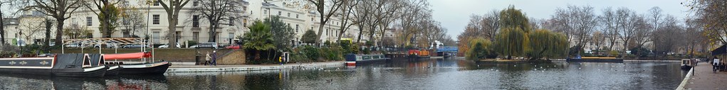
Maida vale station has an interesting mosaic roundel in the foyer above the stairs that lead down to the platforms and the streets nearby are full of what I assume to be Edwardian mansion blocks each with distinctive plasterwork or possibly moulder brick decorations, very attractive. There are a number of blue plaques on this walk including in this area one for David Ben Gurion and another for Alan Turing. After the well hidden Warwick Park station (no buildings above ground just a pair of stairwells, you reach Little Venice which to me is more Little Amsterdam as I've never been to Venice. Narrow bridges over this arm of the Grand Union canal lead to a wide basin full of attractive barges.

LittleVenicePanorama


Leaving the canal and a modern 'urban living' quarter with shops, offices and probably very expensive flats behind there is a labyrinth of roads to negotiate before arriving at Paddington Station (another blue plaque nearby indicates where penicillin was discovered) followed by more busy streets, ugly flyovers and then Edgeware Road station. The fact that there are two Edgeware Road stations must cause endless confusion for tourists!

A stroll along Marylebone Road leads via a detour to Marylebone Station itself which is linked to a nearby hotel by a ornate glazed covered walkway. Baker Street and Regent Park follow in quick succession.
Before reaching Oxford Circus I passed Broadcasting House, the headquarters of the BBC. It gets a lot of bad press from some quarters but I would certainly prefer to live in a country that has something like the BBC rather than one that didn't. The area around Oxford Circus was absolutely rammed with people grabbing a quick lunch and shopping for presents and it took ages to get a snap of the station that didn't have a bus in the way!

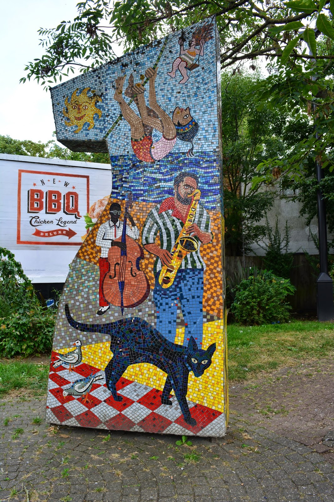
A quick stroll along Carnaby Street with its range of fashionable shops that I would never be seen
dead in (those who know me and my idiosyncratic fashion sense will understand this!) but the area is attractive with several interesting murals and mosaics.

Piccadilly circus is another station that doesn't have any above ground presence - surprising for such an important interchange. On then to Charing Cross, another terminus and then a very short walk down to Embankment station before crossing the Thames to Waterloo.


The wind along the Thames was cold and penetrating but the skies were starting to clear, but not the crowds packing the Southbank.

After Waterloo the crowds thinned slightly and the last two stations as well as the Imperial War Museum came up quickly. Got a bit lost and confused in the maze of tunnels around Elephant and Castle but eventually managed to find the right set of platforms for my journey back up the Bakerloo Line to Oxford Circus and thence back home.

Two lines down now, both diagonal from north west to south east. The District line follows for a more west to east alignment but with several branches to add complexity to the planning.


Friday 1 August 2014

Tracking The Tube: Bakerloo Line 01: Harrow & Wealdstone to Kilburn Park


Weather: Very sunny, warm and humid
Distance Walked: 21.2 km
Distance By Tube: 13.2 km
Stations Visited: 10
Fantastic Place: Mentmore Close


This was not the most inspiring of lines to walk. Most of the northern stretch of the line lies within 1930s suburbia, numerous terraces and associated light industrial units and the North Circular. Still there must be some highlights. In desperation I turned back to Mark Mason's "Walk the Lines" the inspiration behind this project. I spotted that not far 'off the cotton' was the scene of one of my favourite comedy moments so noting that on my route plan I shrugged on my rucksack and set off.


Most of the northern part of the line is shared with mainline services hence the stations are large and lack the traditional Underground architectural aesthetic (ooo get him!). It is not  until I reached Kilburn Park at the end of this leg that I got to see a 'traditional' station building.

Harrow & Wealdstone station has an interesting mural produced by local school children marking the Millennium and all the famous events that have happened in the area. This included a record of the major train collision that happened in 1952 which led to a raft of improvements in rail safety. On the subject of the railways it is worth reading Christian Wolmar's books in particular "Fire & Steam" and "The Subterranean Railway". Both are written in an entertaining style and bring across the chaos and corruption of the early years of the industry.
Walking through light industrial units beside a busy road towards the pleasent open spaces of Kenton Recreation Ground I passed a gloriously colourful Hindu wedding party that lit up the grey drabness of area. The car parks were full to bursting and lots of people were sitting eating rather tasty looking food.

Passing Kenton Station I diverted from the direct route to visit Mentmore Close site of this classic comedy moment.


It would be easier now with the dropped kerb but he'd need to watch out for the bollards.

Should have a blue plaque if you ask me!

The whole estate, in particular the nearby Northwick Circle is an attractive area. This is another of those places I'd never been to nor did I realise that Kenton and Northwick Park stations are so close together, no more than a 5 minute walk yet by tube it would take the best part of an hour and a change of trains at Baker Street!

My route then took me under the tracks at South Kenton where I had a case of deja vu  - this is also the route of the Capital Ring. On to North Wembley through more nondescript suburbia and on to Wembley Central. I'll associate much of this part of the walk with the smell of bins, Friday being collection day, and the large wheelie bins parked on the pavement and in the small front yards were warming up nicely giving off that fragrant aroma you get with heated seepage at their bottom. These seepage has now been given the name farage in one of the 'urban dictionaries.'

Wembley Central has been undergoing building works for some time so I've no idea what the station used to look like hence the rather odd photo! Onwards we travel between high metal fences beside a playing field with Wembley Stadium in the distance.


Stonebridge Park is one of those places I've driven past too many times to mention as it lies on the North Circular road. As a pedestrian it is a maze of road crossings, semi-derelict office blocks and numerous railway lines. The station is up a cul-de-sac and is another of the brick shed style of buildings I've seen before on this leg, Harlesden next up is another. Leading up to Stonebridge Park you pass through the area known as Tokyngton "the farm of the sons of Toca" - not much farmland around now though.

I considered walking along the Grand Union Canal between Stonebridge Park and Harlesden but this section runs through more industrial buildings than you can shake a stick at and may not have been any more interesting than the more direct route.

After Harlesden I came across some attractive mosaics at the junction of Acton Lane and Minet Avenue.


Willesden Junction is a complicated station with lines and platforms running in all directions (which is why it is called a junction I suppose). Took me a while to work out which way to go through the station to end up at the correct exit onto the Harrow Road towards Kensal Green. Willesden Junction is the first of four completely different designs of station. In this case quite modern ticket office on a higher level above the more traditional style platforms. Kensal Green is like a wooden chalet, Queens Park a strange metal box and finally Kilburn Park the first of the traditional blood red tile constructions typical of the main part of the old Underground network.

The walk from Kensal Green to Kilburn Park started to lead into more 'upmarket' properties with gastropubs, the odd art gallery and many eateries. Portuguese restaurants were fairly common, I normally associate Vauxhall where I work with Portuguese shops and cafes but it appears there are at least two little Lisbons in London.  Just before Queen's Park, the area named for Queen Victoria, there is a very pleasant park with an active local preservation group where the QPR football club started.


Next leg will hopefully be more interesting as I head through the heart of the city and out the other side.


Friday 6 June 2014

Tracking the Tube: Metropolitan Line 06: Croxley to Amersham


Weather: Overcast, warm and humid
Distance Walked: 30.1 km
Distance By Tube: c. 19.8 km
Stations Visited: 6
Fantastic Place: Batchworth


Sitting at home looking at a pile of OS maps there seemed no simple way of doing the last few stations in a simple way. Starting from Moor Park was out as there was a nasty bit of road walking to be repeated hence the start from Croxley. The next question I asked myself, am I walking all the tube lines or visiting all the stations? In the end I decided that I would, at least on this leg, visit the stations rather than walking the lines otherwise I would have to either do a zig-zag journey on the tube or walk back from Amersham or Chesham to Chalfont and Latimer.Even when I had made that decision there was the doubt that I would be up to doing the whole lot in one go and I worried that I would be left with one or two stations with a long journey to and from.

Difficult to take photos of some of the stations due to crowds of commuters!

So it was back to Croxley to start the walk and I would see how I would get on. The walk starts with a very pleasant stroll along the Grand Union canal. One day I may look into walking the length of it, assuming there are sensible public transport options. Lots of people fettling their boats, mainly traditional narrow boats but there were a few larger barges, more permanent houseboats and assorted 'floating gin palaces'. As I approached Batchworth there were more and more boats and on the far side large garden shed like constructions. Lots of people shooting the breeze walking dogs and doing repairs. This was a real community of canal boat people almost like a small floating town. At one point a man was ferrying three large dogs, labrador crosses by the look of them, in a small rowing boat when one of the dogs spotted a duck and all three jumped out, nearly capsizing the boat! 

Shortly after Batchworth I turned away from the canal, passing a canal information centre, to reach Rickmansworth, pleasant enough but the station is in the middle of a busy road junction and it was difficult to find the correct road out towards Chorleywood. The next stretch was mainly along suburban streets but it became more and more rural until I was walking along narrow country lanes. One of these lanes passed under the M25 which was supported on a forest of concrete pillars and I could glimpse the tube line running just below the carriageway high above me. Once away from the M25 the open space of Chorleywood Common beckoned and despite getting twizzled  around in Chorleywood Bottom the station was soon reached.

Onward from Chorleywood through more suburban streets until passing through some woodland where I joined the Chiltern Way for a short distance as it headed north till you reach the grounds of the Tudor manor house of Chenies. Here you turn west and walk on a level track through woodland and then the views across the Chilterns and the Chess valley open up to your right. Eventually you drop down into Chalfont & Latimer.

At this point I made up my mind to carry on, the walking had not been too difficult up to this point and as I had aspirations to do a long distance walk with some of my walking friends next year, pushing myself onwards seemed like a good idea.

The path turns northwards through streets until you emerge into woodland and then descend into the Chess valley towards a farm. This is on the site of a former Roman villa but nothing remains above ground. on the hills above stands Latimer House, quite an imposing pile with impressive water features and swans on the river.


The path runs in  front of the house and gives spectacular views across the Chess Valley. 


The path runs level for the most part before dropping down into some small hamlets and narrow lanes before following the river and ending up in Chesham which has a fine range of flint and brick buildings and an attractive high street.

Getting tired now I stopped for a coffee and a sandwich at one of the many coffee shops before stiffly returning to the road.

Following the railway after leaving Chesham then heading through the woodlands near Chesham Bois was hard work. Some climbs and deep muddy tracks from the recent heavy rains made the going tough but eventually I arrived on the A4154 which leads into Amersham. I have visited Amersham several times as it is where I get my needlepoint panels made up into cushions but it was interesting to come in from a different angle. The station was a very welcome sight but has a confusing layout. Seeing a tube train on a far platform I ran up over a bridge and down the other side only to be told that the trains leave from the platform I had just left and so I had to run back over the bridge again and then wait for some time before the train came to take me back home.

So that's the end of the Metropolitan line. Next time I'll be starting at the northern end of the Bakerloo line which will return me once more to the heart of the city.

Friday 14 March 2014

Tracking the Tube: Metropolitan Line 05: Moor Park to Watford


Weather: Sunny and Warm - Perfect walking weather
Distance Walked: 12.9 km
Distance By Tube: 7.6 km
Stations Visited: 3
Fantastic Place: Grand Union Canal


This is where it all gets a bit complicated! The Metropolitan Line starts to bifurcate and deciding which route to go is complicated. Decided, as I was wearing in a new pair of walking shoes (last 'pair' was a mismatch - one was size 8 the other size nine meaning that I had a shoe full of blood and bruised toenails by the end of the walk as I hadn't noticed until near the end), to do a short leg this time.

Some thoughts on a rather complicated journey which in involves two changes to go quite a short distance. At last after 20 years the platform indicators at Sudbury Hill station tell you when and where the next train will be rather than the rather useless "Westbound", "Eastbound" information they used to give! Pinner station has a kiosk selling comestibles on the platform, not many stations have that these days. Northwood station has some very nice flowerbeds

This Walk's Tube Stations
Starting from Moor Park I headed west and then north. I hadn't gone 100 yards before I was stopped by someone asking for directions. This always happens when I'm out walking in somewhere I don't know - do I look like a geography teacher or something? In this case I could help as I had a page from the A to Z with me and was able to point him in the right direction. Heading west along Sandy Lodge Road I was struck by the size and the splendid variety of the properties (once the son of an estate agent, always the son of an estate agent!). Some were huge but all had nice mature gardens and with the spring flowers, sunshine and blossom all looked rather fine. I could almost hear the security cameras whirring and focussing on me as I walked along the deserted road with my camera and notebook!

This idyllic stretch soon changed as the lane joined the busy A4145 which lacked a pavement, in fact in places lacked even a verge to walk on and was very busy.

Pill box in Withey Bed Nature Reserve
I considered walking through the attractive Withey Bed nature reserve but there didn't seem to be a way out on the far side and was looking very damp after the heavy rains of the past three months. Instead I pressed on along the main road for a couple of hundred metres, dodging from side to side as appropriate, being buffeted by the large vans and lorries rushing along to the various light industrial estates that led off from the A4145.

Eventually I turned off into one of these light industrial areas, not the most welcoming of places where there were a number of signs pointing out several local footpaths. including the one I was interested in that would take me across Croxley Common Moor to the Grand Union Canal.

After the busy, noisy, polluted road the moor was a pleasant enough space, it will probably look a lot better in a month or two when all the wild flowers are out. As it was with blue sky overhead it made for easy enough walking and soon I crossed the bridge over the River Gade followed shortly by a second, older bridge, over the canal next to a lock.

Grand Union Canal; Croxley Green Locks
Heading away from the canal for a few minutes I climbed steeply up a narrow lane to the main road and Croxley Station. This station, and Watford later on on this walk, have a distinctive style, more like a pair of large semi-detached houses than a tube station. Retracing my steps I returned to the canal for most of the rest of my journey.


Old car used as a cabin on a barge.


Guardian of the tow path
Peaceful scene on the Grand Union

Willow curtain

Perhaps a project for another day

This was one of the best bits of the walk so far. I like walking by canals as it is hard to get lost, however I also find expanses of still water quite disturbing.

In some places the adjacent river had burst its banks and the canal and river were as one. Lots of birds on the water, I may have glimpsed a kingfisher at one point flying fast and low above the surface of the canal.

Lots of cation on the canal, people fettling their boats after a hard winter and even one or two working boats chugging along carrying supplies of Calor gas from Cassio Wharf and marina to teh boats along this stretch of the canal. Some new houses have been built along this stretch fronting on to the canal while older ones on the west side have gates in their back fences leading down to the tow path. Several people had brought out chairs and some tables to have a morning cup of tea in the warm spring sunshine.

Eventually after passing under major road and rail bridges I climbed up an old canal bridge and walked into Cassiobury Park. A very attractive open space with tree lined avenues and more importantly a very nice cafe by the exit towards Watford station. Very busy at lunchtime with about thirty mothers with attached toddlers I still managed to snag myself a pair of very filling bacon baps and a cup of coffee before heading the short distance to the final stop on this branch, Watford Station. This part of the line is scheduled for closure with a new branch joining up with the mainline station in the centre of Watfrod (this station is some way from the centre). Lots of local protests about this, I may have to revisit if I have time when the new stations are opened.

Next walk will probably be from Croxley to Chalfont & Latimer as this will avoid any more walking along the A4145!

Thursday 13 March 2014

Tracking the Tube: Metropolitan Line 04: Rayners Lane to Moor Park


Weather: Sunny and almost warm!
Distance Walked: 9.3km
Distance By Tube: 7.39km
Stations Visited: 5
Fantastic Place: Pinner


Quite a difference from my previous walk, the sun was out and it almost felt warm. This was the only dry day for weeks so I felt very lucky to be out and about. Spring had started to spring as I managed to spot the first few daffodils on my way to the station. Rather than going backwards and forwards on the tube I walked from Rayners Lane to North Harrow as they are actually not that far apart in real life. The busy road took me past Imperial Court a nice block of 1930's flats. The rather attractive Rayners Pub with equally attractive sign has closed to be replaced by even more flats, probably not as attractive as Imperial Court.

Cambridge Road had a number of large houses with original 1930's stained glass, of birds and pastoral scenes in the doors and hall windows. It's nice that they have been kept. The attractive buildings continue in Nower Hill, older probably Edwardian in age.

Pinner itself is a very attractive village within the mass of cookie-cutter suburbs. The high street has a number of interesting shops and a variety of architectural styles which if I wasn't walking I would certainly have explored.


Early Spring Sunshine on a Pinner Pillar Box
Pinner appears to have an active historical association, some of the older buildings and the church have information plaques.

Fine Mansion in Pinner
Talking of the church, this unusual tomb dominates the graveyard.
Strange Tomb in Pinner Church
The old Victory pub is now an Italian restaurant, the Victory itself (exhibited in Portsmouth) was the scene of many happy visits when I was a small boy. My dad always used to make the joke about the plaque on the deck which says, 'Nelson fell here', saying "Well he should have looked where he was going." Never failed to raise a laugh. Never.

Part of the Characterful Pinner High Street
Managed to get a bit lost in the side streets beyond Pinner before finding myself on Cookoo Hill where there was a fine thatched cottage, something I wasn't expecting to see.

Northwood Hills is fairly nondescript and so I pushed on through before arriving at Northwood. This has an interesting green-man sculpture opposite the station which was possibly the hardest one I've had to get a decent photo of. The junction is busy and so I had to wait for cars, lorries and buses going past as well as large numbers of pedestrians, also the sun was in an awkward position as well.


Northwood itself has an interesting range of shops on the high street and was quite busy. I spent the next half hour or so walking in completely the wrong direction as my directions told me to turn right on Sandy Lodge Lane. However, the road is not called that where it intersects with the High Street and I walked past the turning at least twice before finding Dene Street and walking up there to where it magically changed into Sandy Lodge Lane.

This lane continued up to the Sandy Lodge golf course which was the reason that Moor Park tube station was built. The private estate that has grown up there is very pedestrian unfriendly with limited directions to the station and almost no footpaths. Eventually I found the route I took for the London Loop and followed that to the station. This section was very muddy from a winter of heavy rain and going was quite treacherous.


Thursday 9 January 2014

Tracking the Tube: Metropolitan Line 03: Wembley Park to Rayners Lane


Weather: Cold and Very Wet
Distance Walked: 8.3km
Distance By Tube: 7.03km
Stations Visited: 6
Fantastic Place: Zoroastrian Centre, Rayners Lane


Spot the station NOT photographed on this walk!

I've been putting off blogging this walk, which I did way back in Novemeber, because it was one of the least pleasant walks I've ever done. The forecast when I set out from home was for light drizzle but no sooner had I stepped out of the train at Wembley Park it was already raining heavily. It was so heavy that I couldn't see the stadium from the station. Instead of the planned route I decided to take a direct route. This was a sensible choice as my map was soon transformed to mush in my pocket. 

There was very little of interest on the route, damp suburban streets, major junctions and some busy arterial roads, until I reached Harrow where the school buildings could be glimpsed on the hill (Harrow-On-The-Hill station is not actually on the hill).

The sun eventually came out as I approached the end of the walk and revealed the one gem on the walk, the Zoroastrian Centre near Rayners Lane station.

This fantastic Art Deco building was once a cinema and was worth getting soaked for!

I've decided to do the Rayners Lane to Uxbridge branch when I do the Piccadilly Line walk, and head up the other branch towards Watford, Chalfont and Amersham.