Friday, 6 June 2014

Tracking the Tube: Metropolitan Line 06: Croxley to Amersham


Weather: Overcast, warm and humid
Distance Walked: 30.1 km
Distance By Tube: c. 19.8 km
Stations Visited: 6
Fantastic Place: Batchworth


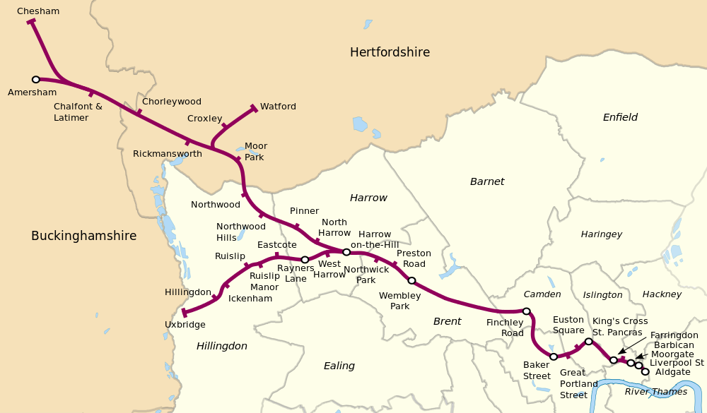
Sitting at home looking at a pile of OS maps there seemed no simple way of doing the last few stations in a simple way. Starting from Moor Park was out as there was a nasty bit of road walking to be repeated hence the start from Croxley. The next question I asked myself, am I walking all the tube lines or visiting all the stations? In the end I decided that I would, at least on this leg, visit the stations rather than walking the lines otherwise I would have to either do a zig-zag journey on the tube or walk back from Amersham or Chesham to Chalfont and Latimer.Even when I had made that decision there was the doubt that I would be up to doing the whole lot in one go and I worried that I would be left with one or two stations with a long journey to and from.

Difficult to take photos of some of the stations due to crowds of commuters!

So it was back to Croxley to start the walk and I would see how I would get on. The walk starts with a very pleasant stroll along the Grand Union canal. One day I may look into walking the length of it, assuming there are sensible public transport options. Lots of people fettling their boats, mainly traditional narrow boats but there were a few larger barges, more permanent houseboats and assorted 'floating gin palaces'. As I approached Batchworth there were more and more boats and on the far side large garden shed like constructions. Lots of people shooting the breeze walking dogs and doing repairs. This was a real community of canal boat people almost like a small floating town. At one point a man was ferrying three large dogs, labrador crosses by the look of them, in a small rowing boat when one of the dogs spotted a duck and all three jumped out, nearly capsizing the boat! 

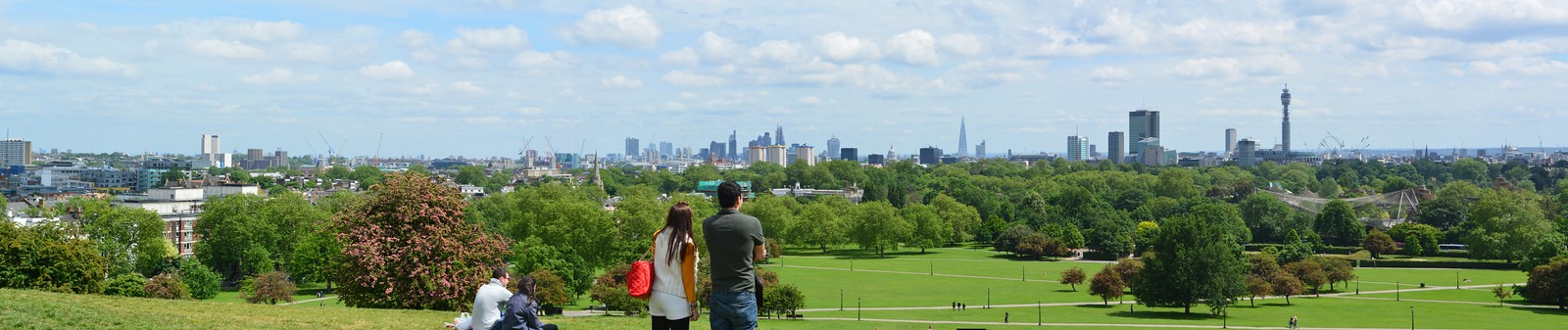
Shortly after Batchworth I turned away from the canal, passing a canal information centre, to reach Rickmansworth, pleasant enough but the station is in the middle of a busy road junction and it was difficult to find the correct road out towards Chorleywood. The next stretch was mainly along suburban streets but it became more and more rural until I was walking along narrow country lanes. One of these lanes passed under the M25 which was supported on a forest of concrete pillars and I could glimpse the tube line running just below the carriageway high above me. Once away from the M25 the open space of Chorleywood Common beckoned and despite getting twizzled  around in Chorleywood Bottom the station was soon reached.

Onward from Chorleywood through more suburban streets until passing through some woodland where I joined the Chiltern Way for a short distance as it headed north till you reach the grounds of the Tudor manor house of Chenies. Here you turn west and walk on a level track through woodland and then the views across the Chilterns and the Chess valley open up to your right. Eventually you drop down into Chalfont & Latimer.

At this point I made up my mind to carry on, the walking had not been too difficult up to this point and as I had aspirations to do a long distance walk with some of my walking friends next year, pushing myself onwards seemed like a good idea.

The path turns northwards through streets until you emerge into woodland and then descend into the Chess valley towards a farm. This is on the site of a former Roman villa but nothing remains above ground. on the hills above stands Latimer House, quite an imposing pile with impressive water features and swans on the river.


The path runs in  front of the house and gives spectacular views across the Chess Valley. 


The path runs level for the most part before dropping down into some small hamlets and narrow lanes before following the river and ending up in Chesham which has a fine range of flint and brick buildings and an attractive high street.

Getting tired now I stopped for a coffee and a sandwich at one of the many coffee shops before stiffly returning to the road.

Following the railway after leaving Chesham then heading through the woodlands near Chesham Bois was hard work. Some climbs and deep muddy tracks from the recent heavy rains made the going tough but eventually I arrived on the A4154 which leads into Amersham. I have visited Amersham several times as it is where I get my needlepoint panels made up into cushions but it was interesting to come in from a different angle. The station was a very welcome sight but has a confusing layout. Seeing a tube train on a far platform I ran up over a bridge and down the other side only to be told that the trains leave from the platform I had just left and so I had to run back over the bridge again and then wait for some time before the train came to take me back home.

So that's the end of the Metropolitan line. Next time I'll be starting at the northern end of the Bakerloo line which will return me once more to the heart of the city.

Friday, 14 March 2014

Tracking the Tube: Metropolitan Line 05: Moor Park to Watford


Weather: Sunny and Warm - Perfect walking weather
Distance Walked: 12.9 km
Distance By Tube: 7.6 km
Stations Visited: 3
Fantastic Place: Grand Union Canal


This is where it all gets a bit complicated! The Metropolitan Line starts to bifurcate and deciding which route to go is complicated. Decided, as I was wearing in a new pair of walking shoes (last 'pair' was a mismatch - one was size 8 the other size nine meaning that I had a shoe full of blood and bruised toenails by the end of the walk as I hadn't noticed until near the end), to do a short leg this time.

Some thoughts on a rather complicated journey which in involves two changes to go quite a short distance. At last after 20 years the platform indicators at Sudbury Hill station tell you when and where the next train will be rather than the rather useless "Westbound", "Eastbound" information they used to give! Pinner station has a kiosk selling comestibles on the platform, not many stations have that these days. Northwood station has some very nice flowerbeds

This Walk's Tube Stations
Starting from Moor Park I headed west and then north. I hadn't gone 100 yards before I was stopped by someone asking for directions. This always happens when I'm out walking in somewhere I don't know - do I look like a geography teacher or something? In this case I could help as I had a page from the A to Z with me and was able to point him in the right direction. Heading west along Sandy Lodge Road I was struck by the size and the splendid variety of the properties (once the son of an estate agent, always the son of an estate agent!). Some were huge but all had nice mature gardens and with the spring flowers, sunshine and blossom all looked rather fine. I could almost hear the security cameras whirring and focussing on me as I walked along the deserted road with my camera and notebook!

This idyllic stretch soon changed as the lane joined the busy A4145 which lacked a pavement, in fact in places lacked even a verge to walk on and was very busy.

Pill box in Withey Bed Nature Reserve
I considered walking through the attractive Withey Bed nature reserve but there didn't seem to be a way out on the far side and was looking very damp after the heavy rains of the past three months. Instead I pressed on along the main road for a couple of hundred metres, dodging from side to side as appropriate, being buffeted by the large vans and lorries rushing along to the various light industrial estates that led off from the A4145.

Eventually I turned off into one of these light industrial areas, not the most welcoming of places where there were a number of signs pointing out several local footpaths. including the one I was interested in that would take me across Croxley Common Moor to the Grand Union Canal.

After the busy, noisy, polluted road the moor was a pleasant enough space, it will probably look a lot better in a month or two when all the wild flowers are out. As it was with blue sky overhead it made for easy enough walking and soon I crossed the bridge over the River Gade followed shortly by a second, older bridge, over the canal next to a lock.

Grand Union Canal; Croxley Green Locks
Heading away from the canal for a few minutes I climbed steeply up a narrow lane to the main road and Croxley Station. This station, and Watford later on on this walk, have a distinctive style, more like a pair of large semi-detached houses than a tube station. Retracing my steps I returned to the canal for most of the rest of my journey.


Old car used as a cabin on a barge.


Guardian of the tow path
Peaceful scene on the Grand Union

Willow curtain

Perhaps a project for another day

This was one of the best bits of the walk so far. I like walking by canals as it is hard to get lost, however I also find expanses of still water quite disturbing.

In some places the adjacent river had burst its banks and the canal and river were as one. Lots of birds on the water, I may have glimpsed a kingfisher at one point flying fast and low above the surface of the canal.

Lots of cation on the canal, people fettling their boats after a hard winter and even one or two working boats chugging along carrying supplies of Calor gas from Cassio Wharf and marina to teh boats along this stretch of the canal. Some new houses have been built along this stretch fronting on to the canal while older ones on the west side have gates in their back fences leading down to the tow path. Several people had brought out chairs and some tables to have a morning cup of tea in the warm spring sunshine.

Eventually after passing under major road and rail bridges I climbed up an old canal bridge and walked into Cassiobury Park. A very attractive open space with tree lined avenues and more importantly a very nice cafe by the exit towards Watford station. Very busy at lunchtime with about thirty mothers with attached toddlers I still managed to snag myself a pair of very filling bacon baps and a cup of coffee before heading the short distance to the final stop on this branch, Watford Station. This part of the line is scheduled for closure with a new branch joining up with the mainline station in the centre of Watfrod (this station is some way from the centre). Lots of local protests about this, I may have to revisit if I have time when the new stations are opened.

Next walk will probably be from Croxley to Chalfont & Latimer as this will avoid any more walking along the A4145!

Thursday, 13 March 2014

Tracking the Tube: Metropolitan Line 04: Rayners Lane to Moor Park


Weather: Sunny and almost warm!
Distance Walked: 9.3km
Distance By Tube: 7.39km
Stations Visited: 5
Fantastic Place: Pinner


Quite a difference from my previous walk, the sun was out and it almost felt warm. This was the only dry day for weeks so I felt very lucky to be out and about. Spring had started to spring as I managed to spot the first few daffodils on my way to the station. Rather than going backwards and forwards on the tube I walked from Rayners Lane to North Harrow as they are actually not that far apart in real life. The busy road took me past Imperial Court a nice block of 1930's flats. The rather attractive Rayners Pub with equally attractive sign has closed to be replaced by even more flats, probably not as attractive as Imperial Court.

Cambridge Road had a number of large houses with original 1930's stained glass, of birds and pastoral scenes in the doors and hall windows. It's nice that they have been kept. The attractive buildings continue in Nower Hill, older probably Edwardian in age.

Pinner itself is a very attractive village within the mass of cookie-cutter suburbs. The high street has a number of interesting shops and a variety of architectural styles which if I wasn't walking I would certainly have explored.


Early Spring Sunshine on a Pinner Pillar Box
Pinner appears to have an active historical association, some of the older buildings and the church have information plaques.

Fine Mansion in Pinner
Talking of the church, this unusual tomb dominates the graveyard.
Strange Tomb in Pinner Church
The old Victory pub is now an Italian restaurant, the Victory itself (exhibited in Portsmouth) was the scene of many happy visits when I was a small boy. My dad always used to make the joke about the plaque on the deck which says, 'Nelson fell here', saying "Well he should have looked where he was going." Never failed to raise a laugh. Never.

Part of the Characterful Pinner High Street
Managed to get a bit lost in the side streets beyond Pinner before finding myself on Cookoo Hill where there was a fine thatched cottage, something I wasn't expecting to see.

Northwood Hills is fairly nondescript and so I pushed on through before arriving at Northwood. This has an interesting green-man sculpture opposite the station which was possibly the hardest one I've had to get a decent photo of. The junction is busy and so I had to wait for cars, lorries and buses going past as well as large numbers of pedestrians, also the sun was in an awkward position as well.


Northwood itself has an interesting range of shops on the high street and was quite busy. I spent the next half hour or so walking in completely the wrong direction as my directions told me to turn right on Sandy Lodge Lane. However, the road is not called that where it intersects with the High Street and I walked past the turning at least twice before finding Dene Street and walking up there to where it magically changed into Sandy Lodge Lane.

This lane continued up to the Sandy Lodge golf course which was the reason that Moor Park tube station was built. The private estate that has grown up there is very pedestrian unfriendly with limited directions to the station and almost no footpaths. Eventually I found the route I took for the London Loop and followed that to the station. This section was very muddy from a winter of heavy rain and going was quite treacherous.


Thursday, 9 January 2014

Tracking the Tube: Metropolitan Line 03: Wembley Park to Rayners Lane


Weather: Cold and Very Wet
Distance Walked: 8.3km
Distance By Tube: 7.03km
Stations Visited: 6
Fantastic Place: Zoroastrian Centre, Rayners Lane


Spot the station NOT photographed on this walk!

I've been putting off blogging this walk, which I did way back in Novemeber, because it was one of the least pleasant walks I've ever done. The forecast when I set out from home was for light drizzle but no sooner had I stepped out of the train at Wembley Park it was already raining heavily. It was so heavy that I couldn't see the stadium from the station. Instead of the planned route I decided to take a direct route. This was a sensible choice as my map was soon transformed to mush in my pocket. 

There was very little of interest on the route, damp suburban streets, major junctions and some busy arterial roads, until I reached Harrow where the school buildings could be glimpsed on the hill (Harrow-On-The-Hill station is not actually on the hill).

The sun eventually came out as I approached the end of the walk and revealed the one gem on the walk, the Zoroastrian Centre near Rayners Lane station.

This fantastic Art Deco building was once a cinema and was worth getting soaked for!

I've decided to do the Rayners Lane to Uxbridge branch when I do the Piccadilly Line walk, and head up the other branch towards Watford, Chalfont and Amersham.


Tuesday, 30 July 2013

A Loughton Circular Walk

I'd never been to Loughton and when the opportunity for a walk through Epping Forest with some of my good walking buddies came up I couldn't refuse. We estimated that it would be about ten miles and with the weather looking good, if a little hot, we arranged to meet at Loughton Station. I'd been through part of the forest before on the LOOP when it passed through Chingford and Buckhurst Hill.

The Route - More or Less

Heading from Loughton Station, which is the third of the name to be built - it seems to have moved about quite a bit, though only the latest, built in 1940 was built for the London Underground. It has particularly attractive gull-wing platform awnings but other than that it isn't anything to write a blog about. Head up Station Road past Lopping Hall (the site of the original station) which was built by the Corporation of London to compensate villagers for the loss of lopping rights in Epping Forest. It is an attractive building with a terracotta frieze showing people lopping branches above the door. Turn left down the high street, then right up Upper Park to Nursery Road, cross this and road and pass beside the nursery and enter the edge of Epping Forest. Turn right on a path heading towards Strawberry Hill ponds. It has to be said the route here is not clear until you find a gravel path leading through the forest.

We were surprised to see lots of small frogs or toads hopping across the gravel path - no more than a few centimetres long - a long journey for them across hostile terrain.

Odd Truncated Branches
Past the ponds you continue north eastwards until you meet and cross the A121 near a small car park. Continuing along the path on the other side of the road you head towards the earthworks at Ambresbury Banks but turn off sharp left before you reach them. The were several odd looking trees in this part of the forest, but as none of us had thought to bring an identification book with us - here is a picture instead.


Bracken Uncurling

There was a lot of bracken in the areas where the tree canopy was broken and the sunlight could stream down.

Heading north after crossing the B1393 you head up a quiet lane to the tall wrought iron gates and a pair of lodges. At first it wasn't clear how to get through till we spotted a small finger sign pointing to a sign gate that wasn't locked just stiff. The next section was a contrast to the earlier part of the walk as this was obviously a managed woodland with specimen trees laid out in an organised fashion. Carrying along the main path you start to notice the M25 for the first time, a constant drown of traffic noise which grows louder and louder until you cross it via a high level bridge.

The landscape changes instantly you cross the M25, becoming open rolling countryside and farmland on both sides of the track and before long you see the run down and ramshackle buildings of Copped Hall ahead on the right. They hold regular events, fund raising for repairs, but it appears to be almost impossible to get there other than by a bus that stops back at the lodge gates. That's fine in the summer but in the winter it might be harder to get people to turn up.

Borage Fields
Passing some rather nice cottages with well tended gardens you turn right past a pond then take a path diagonally across a field at the junction of two tracks (not easy to spot at first). This goes across a field of borage that was being ploughed in as a green manure. The drooping purple flowers and fluffy silver edged green leaves were a mass of fat bumble bees and the air was heavy with their buzzing.

The path, which is not clearly marked on the ground but aim at the yellow topped post on the far side leads into a track that climbs through a glorious meadow filled with wild flowers, bees and butterflies. 


Butterfly on Wild Flower
Bee on Wild Flower


The trail becomes a track that leads into the village of Copthall (note the change of spelling) Green and Upshire which has a fine village sign. Turning south along the Forest Way you recross the M25 by another high level bridge and you can just about see the one you came across earlier in the distance to your left.
You follow this clear path all the way to the High Beech Conservation Centre. Before you reach it there is a large car park where there is a large pub and a little bothy selling cold drinks and ice cream. We paused for a while to recharge our batteries before heading south back towards Loughton.It was a bit of a strain getting going again after sitting on a rather rickety wooden bollard but the pain in my hamstrings distracted me from my stiff knee.

Passing a finger post with a dispiriting "3 Miles to Loughton" indicator and plunging downhill past a pond and then up hill again we reached the outskirts of civilisation once more. This end of Loughton was very hilly and full of rather attractive properties. None too soon we reached the high street and our final destination, a slap up meal in Loch Fyne.

All in all a very pleasing walk with lots of variety and plenty to enjoy which probably turned out to be closer to twelve than ten miles. Well worth the effort.

Tracking the Tube: Metropolitan Line: Leg 02: Finchley Road to Wembley Park


Weather: Hot and Sunny
Distance Walked: 8.7km
Distance By Tube: 7.24km
Stations Visited: 2
Fantastic Plaice: Ever Fresh Fish Cricklewood


The second leg of the Metropolitan Line starts, unsurprisingly, from where I left off. The challenge this time for a walk that only includes two stations was two fold. First to avoid the Jubilee Line stations  that lie on the long stretch between Finchley Road and Wembley Park and how to get across the North Circular road without going too far out of my way.  Leaving Finchley Road and heading north past the wonderfully named Finchley Road and Frognal overground station I was glad to swing west off the busy A41 and enter the shaded and rather attractive side streets of this part of hilly Hampstead. Returning very briefly to the Finchley Road I spied across the busy thoroughfare one of my favourite eating places, Koi Sushi. Many a happy evening has been spent there after a long D&D session and it can be highly reccomended.

Heading down hill past many attractive Edwardian(?) mansion blocks and a very picturesque fire station dating from 1901 you reach Mill Lane which has a very nice village feel. That is something that you pick up when you walk through London, although everything at first appears to be one huge homogeneous metropolis, on the ground many places have kept a part of their original village feel. Hampstead is one of these and even within Hampstead there are different sub-villages and districts.

As the road turns north-west to follow a deep railway cutting there is a small nature reserve tucked into the side of the road. Westbere Copse is quite small and I should have spent a few minutes exploring it but I wasn't sure at the time if there was another way out.

The further north-west I walked along Westbere Road the less attractive the buildings on either side became, you really feel a sense of leaving Hampstead behind and moving into Cricklewood. Ah Cricklewood, this was one of those place names that had a magical attraction for me in my youth as it was the home of The Goodies. I had no idea where it was or what it was like so I made sure that today's walk passed through it. It is quite a busy, bustling place built around and along the A5, the old Roman Road that became in Anglo Saxon times, Watling Street. No sense of ancient history remains in the shop lined street of today though one shop Ever Fresh Fish had one of the finest displays of fresh fish I had ever seen. Fish from all corners of the globe (OK why do we say 'corners of the globe'? Globes have no corners!) bright eyed and very fresh looking. Didn't buy any as I think they may have been a little less fresh by the time I arrived at the end of the walk - it was beginning to get very hot indeed now and the shelter provided by the tall blocks either side of the road was balanced against the fumes from the lorries, buses and cars.

Beyond Watling Street the walk became more peaceful, with parallel streets of residential terraces running south of Olive Road, one of the houses had a very fine dragon finial on their roof which I coveted. I've seen them for sale in reclamation yards, including one near my office in Vauxhall, but they are too expensive (and too heavy to pop in my rucksack) so perhaps in our next house. One of these side streets had my favourite name so far, Dicey Avenue. It would be interesting to find out why that name was chosen, there is no pattern that I could determine; Sneyd,Wren, Dawsons, Blackstone and Heber are the others nearby. It all seems like a difficult Only Connect wall.

A very pleasant walk through Gladstone Park followed, lots of nice trees and . This is one of the numerous municipal parks that are dotted throughout London and which made walking the Capital Ring and this latest project so pleasurable. We are very lucky in London to have so many of them and we need to make sure that in this era of austerity we don't lose them or let them fall into disrepair.It had an interesting bird sculpture which reminded me a bit of some of the art in Barcelona's Park Guell.

Leaving the park, with great views of Wembley Stadium ahead, you enter Neasdon and not far ahead the drone of the North Circular starts to make itself heard. After all my worries it was actually very simple to cross. Following Neasden High Street leads to a very attractive underpass (yes they do exist and not all smell) with tiles depicting canal boats, trains and other forms of transport. I realised as I emerged back into the sunlight that I had been across the top of the underpass on the North Circular hundreds of times but never thought anything of it. A slow climb and walk along a rather busy main road followed before diving south west again towards the station at Wembley Park which has a very attractive frontage. It has obviously been upgraded recently to accommodate extra visitors for the new Wembley Stadium and this has been done very nicely giving the station a nice open feel.

That completed this leg of the walk and next time I need to make a decision as to which branch of the line to tackle first: south to Uxbridge or north to  Chesham, Amersham and Watford.


Monday, 24 June 2013

Tracking the Tube: Metropolitan Line: Leg 01: Aldgate to Finchley Road


Weather: Cloudy and Humid becoming Sunny and Warm
Distance Walked: 12.2 km
Distance By Tube: 10.0 km
Stations Visited: 10
Fantastic Place: Primrose Hill


http://en.wikipedia.org/wiki/Metropolitan_line
Metropolitan Line Map (from http://en.wikipedia.org/wiki/Metropolitan_line)

The 10 Stations
So the first leg of a new challenge. I'm not sure if I've ever travelled to Aldgate before, I certainly didn't recognise the area when I got out! Turning around the first thing I saw was the skeleton of a wooden framed building.

According to the plaque on the ground this marks the location of the historic Aldgate where Chaucer lived from 1374 to 1386. Behind it is one of the iconic new buildings that are dominating the London skyline - the Gherkin. The timber building is inspired by two poems by Chaucer while resident in the two rooms above the now long demolished gate.

The route between Aldgate and Liverpool Street is made more complicated by the amount of building work that is taking place in the heart of London at the moment. Below ground you have the Crossrail project that is well under way now. This means that streets are blocked off as they build new stations, extend existing ones and insert new ventilation shafts and what not.

Around Liverpool Street I found my favourite street name of the walk; Frying Pan Alley. The area has gone upmarket a bit since Jack London wrote about it and there are now parts of the University of East Anglia nearby, many upmarket sandwich shops, wine bars and other services for those travelling into and out of London via one of the busiest mainline termini.

As a part-time baker and the son of a professional baker I liked the images above a sandwich shop near the station. It's a narrow street and I wonder how many people spot these on their rush to buy lunch?

Moving on past Liverpool Street I encountered the first of many diversions due to building above ground as well as more Crossrail works. New office towers are being squeezed into whatever space is available, whether it be by demolishing an ugly 1960's block or into the space between existing towers. One of the spaces I was looking forward to seeing was Finsbury Circus, an oval oasis of green in the glass and concrete world of the city. However this was currently occupied by some of the aforementioned Crossrail works and only a small part was visible. What was open to view looked very nice though and my walking of another of the lines may bring me back.

More diversions on the route to Moorgate station and then a trudge past, around and under the Barbican centre  to Barbican station. I should have walked through the centre rather than around it but I missed the entrance! I always fancied living in the Barbican if I had to live in the centre rather than being able to live in the suburbs. Lots of culture including the Museum of London on your doorstep and some interesting, others may call it ugly and brutalist, architecture.

Between Barbican station and Farringdon I walked along the appropriately named Cowcross street, appropriate as this leads from the fabulous edifice of Smithfield market, the largest meat market in the UK and one of the largest in Europe. There has been a market on the site since the Middle Ages and the current building dates back to the 1850s.

It was also the place that Wat Tyler, leader of the Peasants' Revolt was executed. Sadly there are plans at the moment to demolish part of the historic market as part of a redevelopment plan.

From Farringdon you enter Clerkenwell, a arty-crafty part of London and as I have been before, I was surprised to come across St John's Gate which spans St John's Lane and which was part of a priory owned by the Knights Hospitallers. It's not often I manage to go on a walk that combines two of my favourite hobbies - cooking and Dungeons and Dragons!


After the pretty and historic area around Clerkenwell its a bit of a shock to emerge into the busy, bustling and rather shabby area around King's Cross and St. Pancreas and it is a relief to get off the main drag and into some side streets for a moment, though not before you pass two of my favourite buildings; St Pancreas Station and the British Library.

In one of the quiet squares south of King's Cross there is a statue of Gandhi, a nice peaceful reflective space in amongst the hubbub of the city.

However before long you are back on the main drag to visit Euston Square station and then not much further along, but feeling it because of the busy Euston Road, Great Portland Street station.

More trudging along this busy arterial route follows but at least there are some interesting buildings on either side, along with a huge queue of people outside Madame Tussauds. Now as a Londoner there are many of the famous tourist destinations that I have never got round to visiting, but I will do one day. This however is one that wild horses wouldn't drag me into! Especially when I saw how expensive it was - phew!

Baker Street station is just off of Euston Road and outside it is a plaque celebrating that this was part of the original underground network, built some 150 years ago. Humming Gerry Rafferty's Baker Street as I turned up the street of that name I passed a crowd of tourists taking photos of the actor dressed as a Victorian bobby outside of the famous detective's house at 221b before heading off into Regent's Park. The direct route would have taken me along the busy Finchley Road to the next station but this walk isn't about following the shortest route, but one that leads me through new and interesting places where possible.

Now Regent's Park is one of London's great open spaces and one that I had never visited before. It is a lot larger and in some places wilder than I imagined especially once you have crossed the bridge across the lake and headed into the northern half of the park. There are some nice sculpture in the park as well as great views of the Post Office tower.

Exiting the park past the London Zoo, no I've not been there either, not even as a kid when I was brought up to London by my long suffering elder sister as a birthday treat, you enter another fabulous open space Primrose Hill.

The views from the top of the hill are amazing and you realise how hilly London is with Hampstead and Harrow also on the walk on other parts of this line and elsewhere it won't be a flat trudge that's for sure.
Primrose Hill: http://farm4.staticflickr.com/3698/9042771895_d046cba0fb_h.jpg
Primrose Hill
After finding my way out of Primrose Hill you pass through residential areas, in the garden of one house was a statue of Sigmund Freud,  before plunging down a narrow and rather steep alley to rejoin the Finchley Road and the station of the same name.

Possible idea for my next D&D adventure...
This is one of my regular stops as I have friends nearby but it was interesting to approach it from a new angle.

All in all a very enjoyable walk, it was good to get my boots back on and stride out after far too long thinking about what I was going to do rather than doing it. Looking forward to the next leg northwards along the line towards Wembley.