Friday, 14 March 2014

Tracking the Tube: Metropolitan Line 05: Moor Park to Watford


Weather: Sunny and Warm - Perfect walking weather
Distance Walked: 12.9 km
Distance By Tube: 7.6 km
Stations Visited: 3
Fantastic Place: Grand Union Canal


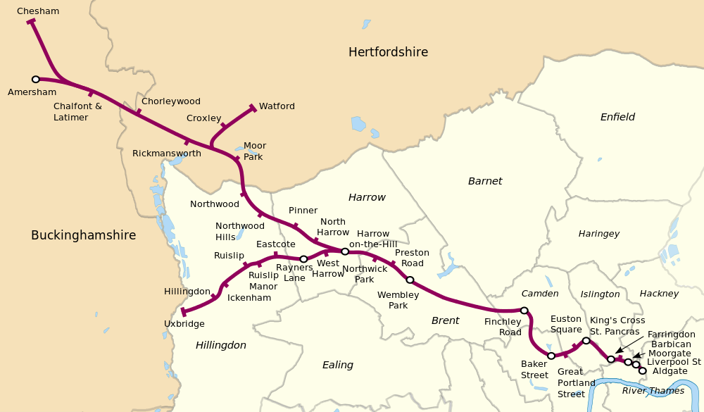
This is where it all gets a bit complicated! The Metropolitan Line starts to bifurcate and deciding which route to go is complicated. Decided, as I was wearing in a new pair of walking shoes (last 'pair' was a mismatch - one was size 8 the other size nine meaning that I had a shoe full of blood and bruised toenails by the end of the walk as I hadn't noticed until near the end), to do a short leg this time.

Some thoughts on a rather complicated journey which in involves two changes to go quite a short distance. At last after 20 years the platform indicators at Sudbury Hill station tell you when and where the next train will be rather than the rather useless "Westbound", "Eastbound" information they used to give! Pinner station has a kiosk selling comestibles on the platform, not many stations have that these days. Northwood station has some very nice flowerbeds

This Walk's Tube Stations
Starting from Moor Park I headed west and then north. I hadn't gone 100 yards before I was stopped by someone asking for directions. This always happens when I'm out walking in somewhere I don't know - do I look like a geography teacher or something? In this case I could help as I had a page from the A to Z with me and was able to point him in the right direction. Heading west along Sandy Lodge Road I was struck by the size and the splendid variety of the properties (once the son of an estate agent, always the son of an estate agent!). Some were huge but all had nice mature gardens and with the spring flowers, sunshine and blossom all looked rather fine. I could almost hear the security cameras whirring and focussing on me as I walked along the deserted road with my camera and notebook!

This idyllic stretch soon changed as the lane joined the busy A4145 which lacked a pavement, in fact in places lacked even a verge to walk on and was very busy.

Pill box in Withey Bed Nature Reserve
I considered walking through the attractive Withey Bed nature reserve but there didn't seem to be a way out on the far side and was looking very damp after the heavy rains of the past three months. Instead I pressed on along the main road for a couple of hundred metres, dodging from side to side as appropriate, being buffeted by the large vans and lorries rushing along to the various light industrial estates that led off from the A4145.

Eventually I turned off into one of these light industrial areas, not the most welcoming of places where there were a number of signs pointing out several local footpaths. including the one I was interested in that would take me across Croxley Common Moor to the Grand Union Canal.

After the busy, noisy, polluted road the moor was a pleasant enough space, it will probably look a lot better in a month or two when all the wild flowers are out. As it was with blue sky overhead it made for easy enough walking and soon I crossed the bridge over the River Gade followed shortly by a second, older bridge, over the canal next to a lock.

Grand Union Canal; Croxley Green Locks
Heading away from the canal for a few minutes I climbed steeply up a narrow lane to the main road and Croxley Station. This station, and Watford later on on this walk, have a distinctive style, more like a pair of large semi-detached houses than a tube station. Retracing my steps I returned to the canal for most of the rest of my journey.


Old car used as a cabin on a barge.


Guardian of the tow path
Peaceful scene on the Grand Union

Willow curtain

Perhaps a project for another day

This was one of the best bits of the walk so far. I like walking by canals as it is hard to get lost, however I also find expanses of still water quite disturbing.

In some places the adjacent river had burst its banks and the canal and river were as one. Lots of birds on the water, I may have glimpsed a kingfisher at one point flying fast and low above the surface of the canal.

Lots of cation on the canal, people fettling their boats after a hard winter and even one or two working boats chugging along carrying supplies of Calor gas from Cassio Wharf and marina to teh boats along this stretch of the canal. Some new houses have been built along this stretch fronting on to the canal while older ones on the west side have gates in their back fences leading down to the tow path. Several people had brought out chairs and some tables to have a morning cup of tea in the warm spring sunshine.

Eventually after passing under major road and rail bridges I climbed up an old canal bridge and walked into Cassiobury Park. A very attractive open space with tree lined avenues and more importantly a very nice cafe by the exit towards Watford station. Very busy at lunchtime with about thirty mothers with attached toddlers I still managed to snag myself a pair of very filling bacon baps and a cup of coffee before heading the short distance to the final stop on this branch, Watford Station. This part of the line is scheduled for closure with a new branch joining up with the mainline station in the centre of Watfrod (this station is some way from the centre). Lots of local protests about this, I may have to revisit if I have time when the new stations are opened.

Next walk will probably be from Croxley to Chalfont & Latimer as this will avoid any more walking along the A4145!
Thursday, 13 March 2014

Tracking the Tube: Metropolitan Line 04: Rayners Lane to Moor Park


Weather: Sunny and almost warm!
Distance Walked: 9.3km
Distance By Tube: 7.39km
Stations Visited: 5
Fantastic Place: Pinner


Quite a difference from my previous walk, the sun was out and it almost felt warm. This was the only dry day for weeks so I felt very lucky to be out and about. Spring had started to spring as I managed to spot the first few daffodils on my way to the station. Rather than going backwards and forwards on the tube I walked from Rayners Lane to North Harrow as they are actually not that far apart in real life. The busy road took me past Imperial Court a nice block of 1930's flats. The rather attractive Rayners Pub with equally attractive sign has closed to be replaced by even more flats, probably not as attractive as Imperial Court.

Cambridge Road had a number of large houses with original 1930's stained glass, of birds and pastoral scenes in the doors and hall windows. It's nice that they have been kept. The attractive buildings continue in Nower Hill, older probably Edwardian in age.

Pinner itself is a very attractive village within the mass of cookie-cutter suburbs. The high street has a number of interesting shops and a variety of architectural styles which if I wasn't walking I would certainly have explored.


Early Spring Sunshine on a Pinner Pillar Box
Pinner appears to have an active historical association, some of the older buildings and the church have information plaques.

Fine Mansion in Pinner
Talking of the church, this unusual tomb dominates the graveyard.
Strange Tomb in Pinner Church
The old Victory pub is now an Italian restaurant, the Victory itself (exhibited in Portsmouth) was the scene of many happy visits when I was a small boy. My dad always used to make the joke about the plaque on the deck which says, 'Nelson fell here', saying "Well he should have looked where he was going." Never failed to raise a laugh. Never.

Part of the Characterful Pinner High Street
Managed to get a bit lost in the side streets beyond Pinner before finding myself on Cookoo Hill where there was a fine thatched cottage, something I wasn't expecting to see.

Northwood Hills is fairly nondescript and so I pushed on through before arriving at Northwood. This has an interesting green-man sculpture opposite the station which was possibly the hardest one I've had to get a decent photo of. The junction is busy and so I had to wait for cars, lorries and buses going past as well as large numbers of pedestrians, also the sun was in an awkward position as well.


Northwood itself has an interesting range of shops on the high street and was quite busy. I spent the next half hour or so walking in completely the wrong direction as my directions told me to turn right on Sandy Lodge Lane. However, the road is not called that where it intersects with the High Street and I walked past the turning at least twice before finding Dene Street and walking up there to where it magically changed into Sandy Lodge Lane.

This lane continued up to the Sandy Lodge golf course which was the reason that Moor Park tube station was built. The private estate that has grown up there is very pedestrian unfriendly with limited directions to the station and almost no footpaths. Eventually I found the route I took for the London Loop and followed that to the station. This section was very muddy from a winter of heavy rain and going was quite treacherous.