Showing posts with label industrial archaeology. Show all posts

Friday, 14 March 2014

Tracking the Tube: Metropolitan Line 05: Moor Park to Watford


Weather: Sunny and Warm - Perfect walking weather
Distance Walked: 12.9 km
Distance By Tube: 7.6 km
Stations Visited: 3
Fantastic Place: Grand Union Canal
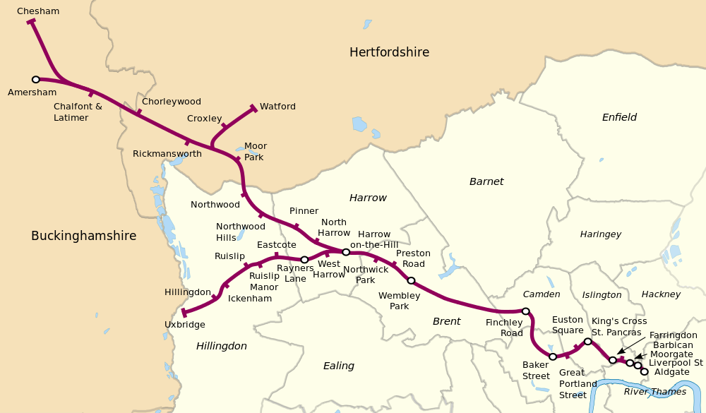


This is where it all gets a bit complicated! The Metropolitan Line starts to bifurcate and deciding which route to go is complicated. Decided, as I was wearing in a new pair of walking shoes (last 'pair' was a mismatch - one was size 8 the other size nine meaning that I had a shoe full of blood and bruised toenails by the end of the walk as I hadn't noticed until near the end), to do a short leg this time.

Some thoughts on a rather complicated journey which in involves two changes to go quite a short distance. At last after 20 years the platform indicators at Sudbury Hill station tell you when and where the next train will be rather than the rather useless "Westbound", "Eastbound" information they used to give! Pinner station has a kiosk selling comestibles on the platform, not many stations have that these days. Northwood station has some very nice flowerbeds

This Walk's Tube Stations
Starting from Moor Park I headed west and then north. I hadn't gone 100 yards before I was stopped by someone asking for directions. This always happens when I'm out walking in somewhere I don't know - do I look like a geography teacher or something? In this case I could help as I had a page from the A to Z with me and was able to point him in the right direction. Heading west along Sandy Lodge Road I was struck by the size and the splendid variety of the properties (once the son of an estate agent, always the son of an estate agent!). Some were huge but all had nice mature gardens and with the spring flowers, sunshine and blossom all looked rather fine. I could almost hear the security cameras whirring and focussing on me as I walked along the deserted road with my camera and notebook!

This idyllic stretch soon changed as the lane joined the busy A4145 which lacked a pavement, in fact in places lacked even a verge to walk on and was very busy.

Pill box in Withey Bed Nature Reserve
I considered walking through the attractive Withey Bed nature reserve but there didn't seem to be a way out on the far side and was looking very damp after the heavy rains of the past three months. Instead I pressed on along the main road for a couple of hundred metres, dodging from side to side as appropriate, being buffeted by the large vans and lorries rushing along to the various light industrial estates that led off from the A4145.

Eventually I turned off into one of these light industrial areas, not the most welcoming of places where there were a number of signs pointing out several local footpaths. including the one I was interested in that would take me across Croxley Common Moor to the Grand Union Canal.

After the busy, noisy, polluted road the moor was a pleasant enough space, it will probably look a lot better in a month or two when all the wild flowers are out. As it was with blue sky overhead it made for easy enough walking and soon I crossed the bridge over the River Gade followed shortly by a second, older bridge, over the canal next to a lock.

Grand Union Canal; Croxley Green Locks
Heading away from the canal for a few minutes I climbed steeply up a narrow lane to the main road and Croxley Station. This station, and Watford later on on this walk, have a distinctive style, more like a pair of large semi-detached houses than a tube station. Retracing my steps I returned to the canal for most of the rest of my journey.


Old car used as a cabin on a barge.


Guardian of the tow path
Peaceful scene on the Grand Union

Willow curtain

Perhaps a project for another day

This was one of the best bits of the walk so far. I like walking by canals as it is hard to get lost, however I also find expanses of still water quite disturbing.

In some places the adjacent river had burst its banks and the canal and river were as one. Lots of birds on the water, I may have glimpsed a kingfisher at one point flying fast and low above the surface of the canal.

Lots of cation on the canal, people fettling their boats after a hard winter and even one or two working boats chugging along carrying supplies of Calor gas from Cassio Wharf and marina to teh boats along this stretch of the canal. Some new houses have been built along this stretch fronting on to the canal while older ones on the west side have gates in their back fences leading down to the tow path. Several people had brought out chairs and some tables to have a morning cup of tea in the warm spring sunshine.

Eventually after passing under major road and rail bridges I climbed up an old canal bridge and walked into Cassiobury Park. A very attractive open space with tree lined avenues and more importantly a very nice cafe by the exit towards Watford station. Very busy at lunchtime with about thirty mothers with attached toddlers I still managed to snag myself a pair of very filling bacon baps and a cup of coffee before heading the short distance to the final stop on this branch, Watford Station. This part of the line is scheduled for closure with a new branch joining up with the mainline station in the centre of Watfrod (this station is some way from the centre). Lots of local protests about this, I may have to revisit if I have time when the new stations are opened.

Next walk will probably be from Croxley to Chalfont & Latimer as this will avoid any more walking along the A4145!

Sunday, 28 August 2011

Two Welsh Walks: 1 - Cemaes Bay to Bull Bay


This walk is part of the Anglesey Coastal Path and as such is clearly signed. On top of that being a coastal path finding the route is dead easy: you just keep the sea on your left and you can't go wrong.
The walk starts in the tidy little village of Cemaes which has a lot of useful shops including a Post Office, vital when you are on holiday and needing to send post to relatives around the world. This is a linear walk, I was dropped off at the start and my wife drove to the Bull Bay Hotel where I would be picked up later (after an obligatory pint (for medicinal purposes only of course)).
Cemaes Bay itself is a striking example of Precambrian geology with folded and twisted rocks of great age. Part of a subduction zone (a destructive plate boundary where one plate is forced beneath another and destroyed, often forming a volcanic island arc in the process). As an ex-geologist this was a particularly interesting part of the walk for me. The path climbs steeply up beside the coast and for much of the route it is very narrow with little separation between the path and the sea some hundred or so feet below.

The route is about six or seven miles in length but it feels a lot longer as there are a number of steep climbs and descents most of the time with steep rough steps but sometimes not. After about the fourth of these climbs my lungs were burning and my head throbbing – walking the London Loop is one thing – tough coastal paths are something else!
There are many signs of industry round the walk, in particular the remains of a wharf and extensive buildings at Porth Wen.


These are the remains of a brickworks I learnt from the barmaid of the Bull Bay Hotel. From this point the path becomes more level and wide making the going easy and at last I was able to enjoy the views of the coast and the heather coated slopes inland. Keep your eyes pealed for wildlife; I think I saw a seal in one of the coves and porpoises are said to swim offshore. Birds are common too; I saw oyster catchers in Cemaes Bay and a kestrel perched on a fence post about twenty paces away from me at one point. I think he was waiting for me to keel over and flew away when he realised I was not going to be supper! There are plenty of viewpoints suitable for a packed lunch, in particular the Lookout Tower on Llanlleiana Head. The walk, though tough in places is well worth the effort and I felt that I had earned my pint at the end.