Showing posts with label wildlife. Show all posts

Sunday, 7 August 2022

Tracking the Tube: Victoria Line 2: Walthamstow Central to Kings Cross


Weather: Blooming Scorching!
Distance Walked: 17.85 km
Distance By Tube: 11.4 km
Stations Visited: 7
Fantastic Place: Woodberry Wetlands


Only 7 stations so I've added the old H&I station for fun.
 
My tube walks are sadly becoming annual events rather than monthly as they used to be. I need to take time out to do more a year, perhaps shorter legs rather than the long ones I've done in the past. 

Today saw the completion of the Victoria Line and I was pleasantly surprised by what I found on this hot sunny summer day. Those of you paying attention may have notice that this year has been one of the hottest and driest on record (a week or so ago we hit 40c which was rather too warm for my tastes!). So the 27c temperature and clear blue skies were not a surprise, I was thankful for the modern water fountains installed by our current London mayor so I could top up my water bottle at regular intervals. Patches of grass on roadsides and parks were a uniform khaki colour and trees, especially horse chestnuts, were already shedding leaves.

The walk started in Walthamstow, former home of William Morris, there is still a museum dedicated to him near the start of the walk. One striking feature of the area are bollards.Most of them seem to have been dressed in woolly jumpers to protect them from the cold - they must have been sweltering in the heat!

Bollards keeping warm

Walthamstow - proud of its heritage

Just past Blackhorse Road station, where there are a lot of new residential tower blocks being built the route continues along a level, straight causeway between two large reservoirs, part of the Lee Valley Reservoir chain. These provide drinking water for London and are also now a important site for water birds such as cormorants. I could see there were footpaths leading around the edges of the water which may make for an interesting visit for the future. On the west side of the reservoirs is the Walthamstow Wetlands. Even from the side of the road I could see that this would be a great place to visit if you like wetlands and wildlife (also a nice looking waterside pub!).
 
Heron on guard duty

 More building and development could be seen near Tottenham Hale station and much light industrial. At this point I should mention that the stations on this leg are nothing to write home about architecturally - the 60's eh!
 
The next leg along Seven Sisters Road was fairly grim, I may have gained a kilo from all the pollution I breathed in so I was quite glad to turn off the road and go rural for a bit . In fact the next section was one of the best bits of any of my tube walks so far. The Woodberry Wetlands is a little lung in this polluted and overcrowded part of London. Two large reservoirs and waterways with birds and plants providing a welcome respite. It also provided lunch at the Coal House Cafe.  I had a very nice cup of coffee and a cheese and fig chutney toastie that set me up nicely for the rest of the walk. The cafe and the wetlands are well worth a visit and are only a short walk from Manor House station (Piccadilly Line - hmm perhaps I will pop in again when I do that line!)


The wetlands have been built in conjunction with a housing development, lots of flats with balconies overlooking the water and a rather nice water feature.


It was back to the Seven Sisters Road for the next station Finsbury Park and the more suburbia before a detour to one of the temples of football the old Arsenal football ground at Highbury (the other is of course the magnificence that is Fratton Park home of the mighty Pompey). Now converted to flats the listed stands still tower above the streets. Down the hill the new Emirates stadium can be glimpsed awaiting a future walk. 

 
The path continues through Highbury Fields, very nice open space but looking very scorched and brown in the sun at the moment. I then got rather twizzled around at Highbury and Islington station, the heat getting to me at last! The last few kilometres were a bit of a grind at the end of a long hot walk but I did pass through a very pretty square surrounded by flats, possibly Edwardian in age which had very nice Gothic details around the windows and doors. 

So that brings to an end the Victoria Line. Now to decide which of the remaining lines to do next and how to break them up in a sensible way!


Tuesday, 30 July 2019

Tracking the Tube: Jubilee Line 04: Neasden to Stanmore


Weather: Very Warm
Distance Walked: 17.01 km
Distance By Tube: 10.2 km
Stations Visited: 6
Fantastic Place: Canons Park


Another year and finally I've completed the Jubilee line.

Guess who forgot to photograph Stanmore Station!
I wasn't looking forward to this leg. From the map it looked like a tough start finding a route next to the very busy North Circular Road and then on through a busy industrial area. This would be followed by lots of dull suburbia walking beside more roads. Now that I only do a few walks a year I'm getting more fussy about the ones I do do and in some ways I resented that this would be possibly one of my final walks of the year.
I wasn't wrong about the start! Grim walking by very busy roads with lots of pollution. At least I had scanned Google Streetview for the start and spotted the alley that took me alongside the A406. Then more walking through light and medium industrial areas, including cement works, and building site after building site. But even here there were moments of beauty, a trailing passionflower draped over a metal fence and a sculpture of a dandelion clock over the River Brent. 
Don't think I'll blow on this one!

The Brent looking rather pretty
I would have liked to get closer to Wembley Stadium but the whole area appears to be one large construction site where flats and apartments are being built in their hundreds if not thousands. I managed to glimpse the arch and had a view back along Olympic Way but that was about it. Some day I will go to a match at Wembley, I can see it from the windows of our loft bedroom and when lit up I can see it when I walk up the hill from Greenford Station, but despite living in London for 30 years I've 'not got round to it.'
The Arch

Olympic Way

New hotel going up alongside Olympic Way

Once past Wembley Park station things got a lot better, less building sites and nice front gardens. Even better was the open expanse of Fryent Country Park. A gentle climb to a ridge that overlooks this part of North London. 
Unlike Kate Bush I was not running up that hill

Damsons

This is London
Lots of mature trees and wide open spaces. At this time of year the hedgerows are full of blackberries, apples (probably from discarded cores) and damsons. Flitting round theme were lots of butterflies, moving to fast to photograph or identify though one might be a small brown. Several very happy dogs being taken for a walk seemed to be enjoying the summer sun and my spirit began to lift. After finding the way out of the park I dropped down into Kingsbury with it's busy row of shops where everyone appeared to be out. Lots of Asian and Caribbean shops with stacks of fresh fruit and vegetables, Asian sweetshops with their pyramids of golden delicacies and everything else you need on a high street. 

Continuing north towards Queensbury via the very attractive Queensbury Park where they have a set of outside exercise equipment. I think these are a good idea, shame they weren't in use. The park also had a nice wetland area with a pond nestling in the centre. The reeds and flowers were busy with dragonflies. with swifts flitting across the water hunting for insects.
Urban wetlands - a vital resource for wildlife

After Queensbury station, a smaller quieter version of Kingsbury, I continued north to Canons Park station and the park of the same name beyond it. This turned out to be the highlight of the walk even thiugh the walled George V memorial garden was closed.


Geoge V Memorial Garden

More building works around Stanmore station, this time for retirement flats, and then a handy bus home after what turned out to be a very pleasing walk.  
So another line has been completed so I'll need to give some thought to what I do next. Waterloo and City for a quick jaunt during the winter? The H&C line, most of which has been done as part of other lines? The Victoria Line which should be able to be knocked off in a couple of days? Or the more substantial PIccadilly Line where it doesn't run alongside the Met Line given that the Central line is being left last? Answers on a postcard to the usual address!

Tuesday, 30 July 2013

A Loughton Circular Walk

I'd never been to Loughton and when the opportunity for a walk through Epping Forest with some of my good walking buddies came up I couldn't refuse. We estimated that it would be about ten miles and with the weather looking good, if a little hot, we arranged to meet at Loughton Station. I'd been through part of the forest before on the LOOP when it passed through Chingford and Buckhurst Hill.

The Route - More or Less

Heading from Loughton Station, which is the third of the name to be built - it seems to have moved about quite a bit, though only the latest, built in 1940 was built for the London Underground. It has particularly attractive gull-wing platform awnings but other than that it isn't anything to write a blog about. Head up Station Road past Lopping Hall (the site of the original station) which was built by the Corporation of London to compensate villagers for the loss of lopping rights in Epping Forest. It is an attractive building with a terracotta frieze showing people lopping branches above the door. Turn left down the high street, then right up Upper Park to Nursery Road, cross this and road and pass beside the nursery and enter the edge of Epping Forest. Turn right on a path heading towards Strawberry Hill ponds. It has to be said the route here is not clear until you find a gravel path leading through the forest.

We were surprised to see lots of small frogs or toads hopping across the gravel path - no more than a few centimetres long - a long journey for them across hostile terrain.

Odd Truncated Branches
Past the ponds you continue north eastwards until you meet and cross the A121 near a small car park. Continuing along the path on the other side of the road you head towards the earthworks at Ambresbury Banks but turn off sharp left before you reach them. The were several odd looking trees in this part of the forest, but as none of us had thought to bring an identification book with us - here is a picture instead.


Bracken Uncurling

There was a lot of bracken in the areas where the tree canopy was broken and the sunlight could stream down.

Heading north after crossing the B1393 you head up a quiet lane to the tall wrought iron gates and a pair of lodges. At first it wasn't clear how to get through till we spotted a small finger sign pointing to a sign gate that wasn't locked just stiff. The next section was a contrast to the earlier part of the walk as this was obviously a managed woodland with specimen trees laid out in an organised fashion. Carrying along the main path you start to notice the M25 for the first time, a constant drown of traffic noise which grows louder and louder until you cross it via a high level bridge.

The landscape changes instantly you cross the M25, becoming open rolling countryside and farmland on both sides of the track and before long you see the run down and ramshackle buildings of Copped Hall ahead on the right. They hold regular events, fund raising for repairs, but it appears to be almost impossible to get there other than by a bus that stops back at the lodge gates. That's fine in the summer but in the winter it might be harder to get people to turn up.

Borage Fields
Passing some rather nice cottages with well tended gardens you turn right past a pond then take a path diagonally across a field at the junction of two tracks (not easy to spot at first). This goes across a field of borage that was being ploughed in as a green manure. The drooping purple flowers and fluffy silver edged green leaves were a mass of fat bumble bees and the air was heavy with their buzzing.

The path, which is not clearly marked on the ground but aim at the yellow topped post on the far side leads into a track that climbs through a glorious meadow filled with wild flowers, bees and butterflies. 


Butterfly on Wild Flower
Bee on Wild Flower


The trail becomes a track that leads into the village of Copthall (note the change of spelling) Green and Upshire which has a fine village sign. Turning south along the Forest Way you recross the M25 by another high level bridge and you can just about see the one you came across earlier in the distance to your left.
You follow this clear path all the way to the High Beech Conservation Centre. Before you reach it there is a large car park where there is a large pub and a little bothy selling cold drinks and ice cream. We paused for a while to recharge our batteries before heading south back towards Loughton.It was a bit of a strain getting going again after sitting on a rather rickety wooden bollard but the pain in my hamstrings distracted me from my stiff knee.

Passing a finger post with a dispiriting "3 Miles to Loughton" indicator and plunging downhill past a pond and then up hill again we reached the outskirts of civilisation once more. This end of Loughton was very hilly and full of rather attractive properties. None too soon we reached the high street and our final destination, a slap up meal in Loch Fyne.

All in all a very pleasing walk with lots of variety and plenty to enjoy which probably turned out to be closer to twelve than ten miles. Well worth the effort.

Tuesday, 11 June 2013

Strolls in Sussex: Two Rings to Rule them All

Weather: Warm and Sunny

This was a simple but very pleasant walk between two Iron Age hill forts in West Sussex. What made it extra special was that I could do it with my wife and being that it was pretty much on the level on wide tracks we could do it side by side discussing what we saw on the way. On hillier routes Liz normally complains that all she sees is a rather large backside...

Anyway... we started the walk by walking around the ramparts of Cissbury Ring, the largest hill fort in Sussex which dates back some 5000 years. From the ramparts you get fantastic views out to the coast and across the Sussex Downs. It was lambing season and everywhere you looked the lambs were gambling and bleating in a very cute fashion. It also gave me an idea for a game to play on walks - lamb bingo. Each lamb tends to have a number on it to match it with its mother so it would be easy to carry a bingo card with you and when you see a lamb or ewe with the appropriate number you can tick it off on your card.

I am not a number, I am a free lamb

After walking around the ramparts (a group was actually jogging round which I felt was a bit extreme) you return past the small car park (I would like to point out that the track out to the ring could have been better signed we kept getting lost in the little village before finding the correct track) and along a wide chalk track with Chanctonbury Ring in the distance.
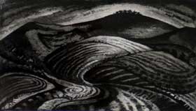
Chanctonbury Ring by Jeremy Blighton
Like the Long Man at Wilmington, we were inspired to do this walk by our shared love of the ancient landscape and our etching by Jeremy Blighton.

The walk is easy as all you need to do is follow the wide track, keeping the tree capped hill of Chanctonbury Ring in view.

Eventually you reach a signpost marking the junction with the South Downs way - something we seemed to cross with somewhat scary frequency on many of the main roads we travelled on our holiday. If I was going to walk the South Downs way I would be concerned at the number of times I had to cross bury dual carriageways - especially if it was towards the end of a long hot day. I remember the same thing happening on the London LOOP, after you've walked twelve miles in the rain or sun there is very little left in the tank for rapid acceleration!

Chanctonbury Ring is smaller and covered with a cap of trees giving it a much more mysterious feel to Cissbury Ring and proved to be a more than acceptable picnic stop before we returned along the same track, this time with a view of Cissbury Ring to guide us back to the car all the while red kites circled around on the strong thermals.